Starting with Sketch-OSM by Place-Maker

This SketchUp plug-in lets you create parametric buildings for Open-Street-Map or the context of your SketchUp model.
You can start by clicking geo-locating your model in the Sketch-OSM toolbar. After that, you can select & import an area.
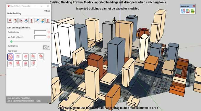
The aerial image is imported and you are taken into Existing Building Preview Mode, where all buildings and road lines in OSM or Open Street Map are displayed. Existing buildings can only be viewed for reference and are not saved or modifiable.
1. Click the Sketch-OSM Dialog button to open it.
2. Log in to OSM or Open Street Map. You'll need to register an account or use a third party to do this. After login, you should see the Sketch-OSM dialog box.
3. As you switch from one tool to another, existing buildings will disappear. To return to Preview Mode, click "Import Existing Buildings and Road Lines from OSM."
4. Draw a face like Rotated Rectangle, Line, etc using a SketchUp tool to create a building.
5. You can trace a blueprint of a building's footprint.
6. By clicking "Create Buildings", you will be able to create the face.
7. In the Sketch-OSM Dialog, the attributes of the selected building or part are displayed. Textboxes for adding Building Height can be found here.
Download Sketch-OSM by Place-Maker
About OSM
Open-Street-Map or OSM is a collaborative online mapping project that is supported and created by many people across the globe. It is similar to Wikipedia since users may contribute additional information such as photos or GPS data collected by GPS devices.
To learn more, watch the following video tutorial.
Video Source: mind.sight.studios
This open-source project enables the development and distribution of geospatial data to millions of users worldwide. OSM provides map data to thousands of websites, mobile apps, and other services.
OSM's sheer amount of freely available data coupled with its open-source license makes it the perfect companion for SketchUp. You can import OSM data into your SketchUp project to add context and impact. For instance, model existing urban tissue using OSM data.